


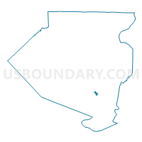
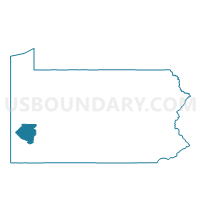
DRAVOSBURG DIST 03, Allegheny County, Pennsylvania
About
Outline

Summary
| Unique Area Identifier | 655830 |
| Name | DRAVOSBURG DIST 03 |
| County | Allegheny County |
| State | Pennsylvania |
| Area (square miles) | 0.40 |
| Land Area (square miles) | 0.36 |
| Water Area (square miles) | 0.04 |
| % of Land Area | 90.28 |
| % of Water Area | 9.72 |
| Latitude of the Internal Point | 40.34880610 |
| Longtitude of the Internal Point | -79.89467960 |
Maps

Graphs
Select a template below for downloading or customizing gragh for DRAVOSBURG DIST 03, Allegheny County, Pennsylvania


Neighbors
Neighoring Voting District (by Name) Neighboring Voting District on the Map
- DRAVOSBURG DIST 01, Allegheny County, PA
- DRAVOSBURG DIST 02, Allegheny County, PA
- GLASSPORT DIST 01, Allegheny County, PA
- MC KEESPORT WD 10 DIST 01, Allegheny County, PA
- WEST MIFFLIN DIST 10, Allegheny County, PA
- WEST MIFFLIN DIST 11, Allegheny County, PA
- WEST MIFFLIN DIST 12, Allegheny County, PA
Top 10 Neighboring County Subdivision (by Population) Neighboring County Subdivision on the Map
- West Mifflin borough, Allegheny County, PA (20,313)
- McKeesport city, Allegheny County, PA (19,731)
- Glassport borough, Allegheny County, PA (4,483)
- Dravosburg borough, Allegheny County, PA (1,792)
Top 10 Neighboring Place (by Population) Neighboring Place on the Map
- West Mifflin borough, PA (20,313)
- McKeesport city, PA (19,731)
- Glassport borough, PA (4,483)
- Dravosburg borough, PA (1,792)
Top 10 Neighboring Unified School District (by Population) Neighboring Unified School District on the Map
- McKeesport Area School District, PA (31,150)
- West Mifflin Area School District, PA (21,584)
- South Allegheny School District, PA (11,904)
Top 10 Neighboring State Legislative District Lower Chamber (by Population) Neighboring State Legislative District Lower Chamber on the Map
Top 10 Neighboring State Legislative District Upper Chamber (by Population) Neighboring State Legislative District Upper Chamber on the Map
Top 10 Neighboring 111th Congressional District (by Population) Neighboring 111th Congressional District on the Map
Top 10 Neighboring Census Tract (by Population) Neighboring Census Tract on the Map
- Census Tract 4886, Allegheny County, PA (4,942)
- Census Tract 4885, Allegheny County, PA (2,843)
- Census Tract 4870, Allegheny County, PA (1,792)
- Census Tract 4993, Allegheny County, PA (1,574)
- Census Tract 5522, Allegheny County, PA (1,100)